Storage & Organization up to 60% OFF!
Plus, a FREE Gift! | Details Here.
Plus, a FREE Gift! | Details Here.

 Give a Cheer
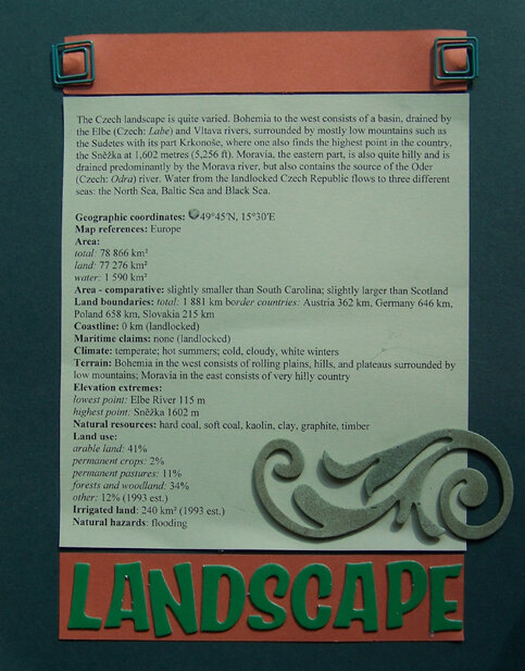
The Czech landscape is quite varied. Bohemia to the west consists of a basin, drained by the Elbe (Czech: Labe) and Vltava rivers, surrounded by mostly low mountains such as the Sudetes with its part Krkonoe, where one also finds the highest point in the country, the Sněka at 1,602 metres (5,256 ft). Moravia, the eastern part, is also quite hilly and is drained predominantly by the Morava river, but also contains the source of the Oder (Czech: Odra) river. Water from the landlocked Czech Republic flows to three different seas: the North Sea, Baltic Sea and Black Sea.
Geographic coordinates: 49°45′N, 15°30′E
Map references: Europe
Area:
total: 78 866 km²
land: 77 276 km²
water: 1 590 km²
Area - comparative: slightly smaller than South Carolina; slightly larger than Scotland
Land boundaries: total: 1 881 km border countries: Austria 362 km, Germany 646 km, Poland 658 km, Slovakia 215 km
Coastline: 0 km (landlocked)
Maritime claims: none (landlocked)
Climate: temperate; hot summers; cold, cloudy, white winters
Terrain: Bohemia in the west consists of rolling plains, hills, and plateaus surrounded by low mountains; Moravia in the east consists of very hilly country
Elevation extremes:
lowest point: Elbe River 115 m
highest point: Sněka 1602 m
Natural resources: hard coal, soft coal, kaolin, clay, graphite, timber
Land use:
arable land: 41%
permanent crops: 2%
permanent pastures: 11%
forests and woodland: 34%
other: 12% (1993 est.)
Irrigated land: 240 km² (1993 est.)
Natural hazards: flooding
No products have been added to this project.


Thanks for spreading positivity!


September 04, 2008
September 04, 2008
September 04, 2008
August 29, 2008
August 23, 2008
August 22, 2008
August 20, 2008
August 20, 2008
August 20, 2008