


Thank YOU! It's Customer Appreciation Week!
EXTRA 11% OFF Orders $100+ With Code: THANKYOU
EXTRA 11% OFF Orders $100+ With Code: THANKYOU


 Give a Cheer
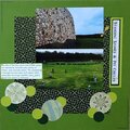
This is the intro to our next hike. I knew that I had a lot of journaling and was trying to come up with a design when I remembered the Pocket Page design or grid - which worked great for this! pp, die cuts stickers - Simple Stories, enamel dots - PinkFresh & Eyelet Outlet, brad - HOTP, twine - stash. I used a postcard for the Javelina
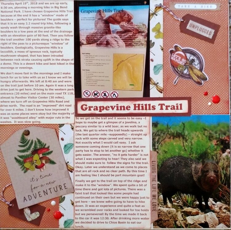
Journaling: Thursday April 19th, 2018 and we are up early, 6:30 am, planning a morning hike in Big Bend National Park. I have chosen Grapevine Hills Trail because at the end it has a window made of boulders perfect for pictures! The guide says that it is an easy 2.2 round trip hike, following a sandy wash through massive granite-like boulders to a low pass at the end of the drainage with an elevation gain of 80 feet. Then you follow the trail another 100 yards along a ridge to the right of the pass to a picturesque window of boulders. Geologically, Grapevine Hills is a laccolith, a mass of igneous rock, typically mushroom-shaped, that has been intruded between rock strata causing uplift in the shape of a dome. This is a desert hike and best hiked in the mornings or evenings.
We dont move fast in the mornings and I make lunch for us to take with us as I know we will be hungry afterwards. We left at 8:40 am and were on the trail just before 10 am. Again it was a long drive just to get here. Driving to the western park entrance (20 miles) and on the main road TX 118, almost to Panther Visitor Center (30 miles), where we turn off on Grapevine Hills Road and drive north. The road is an improved dirt road for over 6 miles. I dont know how improved it was as some places were okay but the majority of it was washboard alley with major ruts in the washes. It was slow going.
So we get on the trail and it seems to be easy I hope to maybe get a glimpse of a javelina, a peccary similar to a wild boar, as we walk but no luck. We get to where the trail heads upwards (the last quarter mile supposedly) straight up rock with some steps carved and very narrow. Not exactly what I would call easy. I ask someone coming down (it is so narrow that one party has to stop to let another go) whether it gets easier. The answer, no it gets harder is not what I was expecting to hear! They also said we should make sure to follow the signs for the trail. Okay. Later we understand as we come to places that are all rock and no clear path. By this time I am feeling like I should be part mountain goat!
Finally we get to the trail on top of the ridge and make it to the window. We spent quite a bit of time there and got lots of pictures. There was a faint trail that looked like some people had continued on their own but we were happy just to get here we knew were going to have to hike down. It was an experience and quite a feat as we scrambled over rocks and looked for toe holds but we persevered! By the time we made it back to the car it was 12:30. After drinking more water we decided to drive to Chios Basin to eat our lunch.
Journaling challenge


Thanks for spreading positivity!


October 17, 2020
October 09, 2020
October 09, 2020
October 09, 2020
October 09, 2020
October 08, 2020
October 07, 2020
October 07, 2020
October 07, 2020
October 07, 2020